literatur.social ist einer von vielen unabhängigen Mastodon-Servern, mit dem du dich im Fediverse beteiligen kannst.
Der Einstieg ins Fediverse für Autor:innen und Literaturmenschen ... The gateway into the fediverse for authors and all people interested in literature.

Verwaltet von:

Serverstatistik:

306
aktive Profile

#gpx

2 Beiträge2 Beteiligte0 Beiträge heute

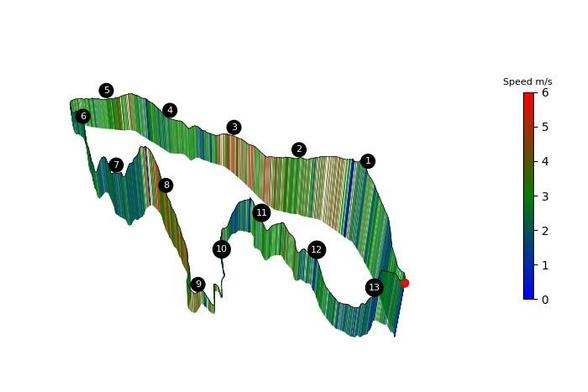
I think i found a good way to visualize runs and might work even when comparing similar ones, but in the meantime if you want to create a 3d elevation profile of your workout give this a go:

curbal.world/upload

I know that if the track is too long the lap numbers will overlap and there are a ton more improvements that can be done, but it is a start.

Also know that it is hosted on pythonanywhere as a small app, it might crash…

#runnersofmastodon #running #run #garmin #gpx

Going to 😴

Shortly after the aquisition of #Komoot by Italian #PrivateEquity firm #BendingSpoons about 80% of its staff has already been fired.

When logging into the account the main page does not show anymore the latest activities of the followed people... It may be a good idea to download all traveled and plannend #tracks as #GPX files on the #computer - just to be on the safe side.

#BikeTooter #vélo #fahrrad #fahrradbubble #cycling #bike #cyclotourisme #biking #fahrradbubble

escapecollective.com/how-komoo

Escape Collective · How Komoot lost its wayMere days after the announcement of acquisition by an Italian tech firm, the route-planning platform laid off 80% of its staff, and former employees fear for its future.

#Biketooter :When planning a #bike #route with #FOSS and #OSM based #routing engines, such as #Brouter / #Bikerouter ,the result analysis frequently shows some #surface percentage as "unknown". I guess that's because the #information is missing in the #OpenstreetMap #database .However, when I upload the same track as #GPX into a #commercial #biking application, such as #Komoot or #Cyclers ,the unknown has disappeared, while they are also based on OSM. How come?

I once again recommend to pull the *.GPX files from your fitness tracker and view them in blender!

Shown is a section of my bike bike commutes (and fun rides around town) form 2022 to today, spanning at least 6000km

You can use this add on I made for that purpose. Even if #b3d is switching to the new extensions platform! Just select "Install from disc..." and you're set.

zuggamasta.de/projects/gpximpo

I have lots of favorites (starred places) in #OSMand and I want to view them on a map on a bigger screen, not just on the phone. When I export them, I get a favorites.gpx file.

As far as I understand, these are waypoints on a track?

I opened the file in the nextcloud map, and it displays the points, but without any text.

The entries look like this:

<wpt lat="51.5320587" lon="-0.1773316">
<time>2025-01-18T22:23:30Z</time>
<name>Abbey Road Crossing</name>
<extensions>
<osmand:amenity_subtype>attraction</osmand:amenity_subtype>
<osmand:address>Abbey Road (South Hampstead), Camden Town</osmand:address>
<osmand:amenity_origin>Amenity:Abbey Road Crossing: tourism:attraction</osmand:amenity_origin>

I tried converting the file to (geo)json, but so far the file has come out empty. I realize I don't really know what I'm looking for. It doesn't have to be nextcloud compatible at all, that was just the first thing I had on hand.

I would like to see the points and their names on a map on a bigger screen.

Any suggestions please?

#android#app#osm

Tijdens al mijn wandelingen gebruik ik GPS op mijn mobiele telefoon. Zo weet ik precies waar ik heen moet als ik een ongemarkeerde wandelroute loop of als de routebeschrijving niet geheel duidelijk is. Ik krijg regelmatig de vraag wat is GPX en GPS, wat zijn GPX-bestanden, wat is GPS-wandelen, hoe doe je dat en wat heb je ervoor nodig. Je leest het in deze blog. Veel wandelplezier. 👇

jtravelblog.nl/wandelen-met-gp

Mein Workflow, wenn ich eine Strecke plane oder auf dem #Garmin haben möchte:

- #GPX erstellen (bevorzugt mit bikerouter.de, weil es gibt nichts besseres!)

- GPX Datei auf Garmin kopieren (#Cloud Sync von Garmin oder File-Sync am Desktop)

Fertig.

Wüsste gar nicht, wobei ich mit #Komoot einen Vorteil gehabt hätte, wenn ich die Plattform genutzt hätte, die mit dem Verkauf von #OSM-Karten Geld macht(e).

Ich bin heute auf der Suche nach …

… einem möglichst vollwertigen Ersatz für Garmins Basecamp.

Nachdem ich mittlerweile mit der Einkaufsliste / Bestandsverwaltung #Grocy (mstdn.mv2k.com/deck/@memo/1139) sehr zufrieden bin, ist die letzte #Software, die mich noch an #Windows bindet - #Basecamp (garmin.com/de-DE/software/base).

Sollte ich einen passenden Ersatz für #Linux finden, kann ich mich komplett von #Microsoft verabschieden 😀

Die Alternative sollte #GPX Dateien importieren und im Anschluss editieren ‼️ können, sowie möglichst #OpenStreeMap als #Kartenmaterial verwenden. Das Einbinden anderer Karten wie zum Beispiel der #OFM (OpenFietsMap openfietsmap.nl/) wäre ein nicht zu verachtender Bonuspunkt.

Zurzeit nutze ich die “Organic Maps Betaversion” (organicmaps.app/de/) und zum Bearbeiten den “Viking GPS data editor” (sourceforge.net/p/viking/wikia).

Das funktioniert (irgendwie) ist aber für den ständigen, oder schnellen Gebrauch nicht die Ideallösung ¯\_(ツ)_/¯

#Garmin#Map#OpenSource